
The Ripple Effect – ponds for wildlife, people and climate
A pioneering project, creating and restoring 100 ponds across the Meriden Gap, Solihull and Coventry - boosting biodiversity, water quality and climate resilience to benefit local wildlife, communities and businesses.
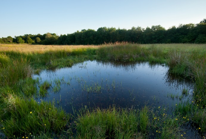
This project is run by Warwickshire Wildlife Trust.
Other organisations/groups involved in the project:
Coventry City Council, Solihull Metropolitan Borough Council, Environment Agency, Parish Councils, community groups, schools, farmers and landowners, etc.

Project details
More than half of Britain’s ponds have been lost since the 1900s due to agricultural change and urban growth, despite ponds being one of the most effective ways to boost biodiversity and climate resilience. This pioneering project will create and restore a connected network of ponds across the Meriden Gap, Solihull and Coventry, revitalising the landscape as a functioning wetland network. By re‑establishing habitat “stepping stones”, wildlife will be able to move more easily through the area, supporting a wide range of species, particularly declining amphibians such as the common toad.
Each carefully designed pond provides nature‑based solutions that deliver measurable environmental outcomes and long‑term community benefits, aligning strongly with ESG commitments. The ponds will help reverse regional declines in freshwater species while increasing the landscape’s ability to store carbon, manage water and withstand climate pressures. Newly created or restored ponds will include surrounding planting, earth shaping and selective fencing where needed to maximise biodiversity while remaining compatible with land use. Delivered through strong local partnerships and shovel‑ready plans, the project offers a compelling opportunity to invest in nature and deliver visible benefits for wildlife and communities.
Scheme / Programme
The Ripple Effect project sits within Nature4Water, a partnership led by Warwickshire Wildlife Trust with Severn Trent, the Environment Agency and Warwickshire County Council. Nature4Water shows how investing in nature strengthens water systems—reducing flood risk, improving water quality, storing carbon, boosting biodiversity and supporting health through nature‑based solutions.
Scale
The scale of this project is 1,000m².
Project delivery timeline
After funding has been secured the next step involves finalising permissions, permits and contractors to deliver the works. This could take up to 6 months due to partner availability. Pond creation would typically occur in the 6 months after that and works are best completed in the autumn/winter. If groups of ponds are funded together then the process could benefit from efficiency savings.
Community involvement
There are currently 10 volunteers for every one staff member involved in the project at all phases. Local communities will be involved in confirming the exact position of new ponds. They will also be involved in planting the habitats surrounding the ponds.


Funding secured / committed
This project can be funded in its entirety or in parts as follows:
£10,000
per pond
Total funding required:
£1 million
If you are interested in supporting this project, contact us using the button below.
Ecosystem services & nature recovery
This project will deliver 24 priority actions in the West Midlands Local Nature Recovery Strategy.
The project will deliver the following environmental, economic, and social benefits:
- B5 - Reduce barriers to species movement in areas where habitat connectivity is important
- B6 - Collaborate to enable development of large-scale rewilding projects to support nature recovery and greater resilience of biodiversity
- C2 - Maintain, improve and create new pond networks
- C3 - Maintain, improve and create wetland habitats
- E1 - Create stepping stone habitats in areas where corridors cannot be established
- E2 - Implement Natural England’s Green Infrastructure Framework, within new and existing developments across both public and private spaces
- E3 - Increase the structural and species diversity of habitats within public and private green spaces, and gardens
- F1 - Water vole
- F2 - Otter
- F3 - White-clawed crayfish
- F8 - Black poplar
- F9 - Urban birds
- F10 - Farmland birds
- F12 - Amphibians and reptiles
- F17 - Bats
- F21 - Beaver
- G1 - Create new accessible green spaces that benefit nature and people
- G2 - Improve awareness on sensitivity of sites and habitats to increased access
- I1 - Increase coordinated monitoring of the region’s biodiversity
- I2 - Collect further evidence to evaluate the risk of climate change upon our region’s nature
- I3 - Create a strong evidence base to support and develop nature finance opportunities to drive nature recovery and nature-based solutions forwards.
Project impact & reporting
The project delivery organisation will provide an annual progress report and a final project report against the following targets:
10 species surveys
If 50 ponds are funded it would provide enough economies of scale to integrate eDNA water sampling costs into the project. That would enable us to DNA test the water within the ponds 1 year after establishment to obtain accurate assessments of the different species which have interacted with each pond since it’s creation.
200 cubic metres
Surface area: 20 m × 20 m = 400 m²
Maximum depth in the centre: 1 m
Depth at the edges: 0 m
Shape: roughly a shallow bowl (sloped evenly from centre to edge)
For a pond that slopes evenly from 1 m at the centre to 0 m at the perimeter, a good approximation is:
Average depth ≈ ½ × maximum depth
→ Average depth ≈ 0.5 m
(This approximation is commonly used for grading calculations when slopes are linear.)
Volume = surface area × average depth
Volume = 400 m² × 0.5 m = 200 m³
Estimated volume: ~200 cubic metres of water
10 days
Estimate based on activities associated with one pond being created or restored. Volunteers could include planting around the margins of the ponds to help establishment, surveying pre or post creation to assess biodiversity enhancement.
4 full-time jobs supported
The River & Catchment Restoration Team at Warwickshire Wildlife Trust will lead this work. The team is comprised of a Manager and 3 Officers.
WMCA will produce an annual social and environmental impact report detailing the scale of benefits delivered across the region and acknowledging the contributions made by Funding Partners.
Funding
This project can be funded in its entirety or in parts as follows:
£10,000
per pond
Total funding required:
£1 million
If you are interested in supporting this project, contact us using the button below.
Share this page